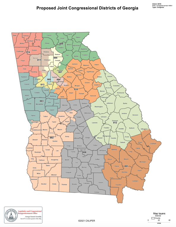
ATLANTA – Republican lawmakers on Wednesday released a new congressional map that would make one metro Atlanta district more friendly to the GOP while leaving another solidly in Democratic hands.
The General Assembly has been meeting in special session for two weeks as lawmakers redraw legislative and congressional boundaries in accordance with new U.S. Census data.
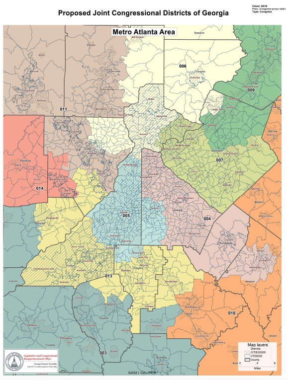
The new congressional map adds more white voters to Democratic U.S. Rep. Lucy McBath’s 6th Congressional District by extending it north through all of Forsyth and Dawson counties and eastern Cherokee County. As a result, the 6th District’s white voting-age population would increase to 66.63%.
On the other hand, Rep. Carolyn Bourdeaux’s 7th District taking in most of Gwinnett County and a portion of North Fulton County would remain a majority-minority district.
An alternative map introduced by the state House and Senate Democratic caucuses would make little change to McBath’s district, leaving it competitive, while keeping Bourdeaux’s majority-minority district wholly inside Gwinnett County.
Legislative Democrats and civil and voting rights advocates criticized the Republican congressional map at House and Senate committee hearings Wednesday as ignoring communities of interest in favor of giving the GOP a partisan advantage.
Maggie Goldman, a Democrat from Johns Creek, complained that moving McBath’s district north through Forsyth and Dawson counties was politically motivated.
“Dawson and Forsyth have nothing to do with Sandy Springs except to create a majority white district,” Goldman told members of the Senate Reapportionment and Redistricting Committee.
Others complained that the Republican map packs Black voters into certain districts to dilute their voting strength while spreading out GOP voters to maximize their power.
Rep. Bonnie Rich, R-Suwanee, chairman of the House Legislative & Congressional Reapportionment Committee, denied the accusations. She said Georgia’s rapid population growth in metro Atlanta during the last decade coupled with population losses in rural South Georgia made it necessary to move districts to the north.
“We drew our maps based on population shifts,” Rich said.
“We think this map fairly represents all Georgians,” added Sen. John Kennedy, R-Macon, chairman of the Senate redistricting panel. “It is not gerrymandered.’
The two committees will continue discussing the competing congressional maps on Thursday.
Late last week and early this week, lawmakers passed new state House and Senate maps amid protests from Democrats that the maps were drawn in secret and without enough time for public comment.
Capitol Beat Bureau Chief Dave Williams contributed to this report.
This story is available through a news partnership with Capitol Beat News Service, a project of the Georgia Press Educational Foundation.